


The nonprofit Environmental Working Group was an early leader in PFAS research and advocacy, publishing reports on the toxicity of PFOA in 2002 based on documents made public through the work of attorney Rob Bilott, who brought a federal class-action suit against DuPont, the company that produced Teflon, for polluting local water supplies in West Virginia and Ohio. A 2019 film, “Dark Waters,” dramatizes the story.
![]()
Read the findings at http://www.c8sciencepanel.org/
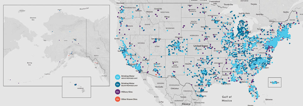
Research by the Environmental Working Group and the PFAS Project at Northeastern University’s Social Science Environmental Health Research Institute has helped to map the crisis of contamination with the toxic fluorinated chemicals known as PFAS, now recorded at more than 1,400 locations in 49 states.
This project brought significant public, media and legislative attention to the issue of widespread PFAS contamination. Since 2017, the project has led to more than 600 news stories and more than 860,000 map views.
The map shows high levels of forever chemicals in drinking water at the former Fort Ord and Fort Hunter Liggett due to use of firefighting foam and also in groundwater at Moffett Field, with firefighting foam suspected as the source. The levels at the Alameda Naval Air Station are off the charts, again firefighting foam is suspected.
EWG reports actionable levels at the Santa Cruz Water Department, City of Watsonville, and San Lorenzo Valley Water District, the Sheriff’s Rehab, and the Buena Vista Migrant Center.
EWG reports below the actionable levels at Scotts Valley Water District and San Andreas Mutual Water.
The Soquel Creek Water District does not appear on the map.
•••
View the map at https://www.ewg.org/interactive-maps/pfas_contamination/