

By Kevin Newhouse
It was 5:04 pm when the ground started to shake. Game 3 of the World Series between the San Francisco Giants and the Oakland A’s was set to begin at 5:35. Millions of people were tuned in to watch the pre-game festivities at Candlestick Park when the earthquake hit. It was the first time ever a major earthquake in the United States was broadcast live by television.
It was the largest earthquake to occur on the San Andreas Fault since the 8.3 magnitude quake on April 18, 1906, which shook for over a minute. 1906 had experienced a good deal of rain leading up to the quake. The hillsides were saturated and as the earth began to shake and Hinckley Creek in today’s Forest of Nisene Marks State Park was the scene of a deadly landslide. It was reported the slide was 500 feet wide, descended with extraordinary speed, and buried the Loma Prieta Lumber Mill under a mass of rock and trees of about 100 feet in depth. At least eight people were killed as a result of the slide. Some reports claim nine. More than a year had passed before the last body was finally removed from the debris.
There were, however, 63 people that died for other reasons as a result of the 1989 quake, six being Santa Cruz County residents. Approximately 3,757 people were injured and there was an estimated $6 billion in property damage. The Highway One Bridge over Harkins Slough in Watsonville collapsed. Downtown Santa Cruz suffered most of the county’s major structural damage. To this day, the demolition of the Cooper House is a bitter topic among those who believe the wrecking ball came too quick, despite how many experts had agreed the building was unsafe and could not be saved for any reasonable amount of money. Just 10 days after the quake, the 94-year old building met its tragic demise.
A historic piece of Aptos Village was also lost as a result of the Loma Prieta earthquake. A block-long portion of the historic village located across from the Bay View Hotel was red-tagged by the county as it was left teetering on damaged piers over the Aptos Creek Ravine. At first it appeared the businesses might be saved with a bit of repairs and at the very worst, the buildings would be demolished and rebuilt.
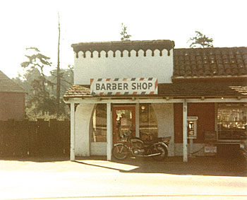
However, on November 8, 1989, one of the buildings that had been sitting atop damaged piers collapsed into the deep ravine of Aptos Creek. The Montad furniture store was one of the businesses lost. The Colonial Barber Shop, which was originally the first telephone exchange in Aptos, was also lost in the tumble.
Paul Johnston, a longtime Aptos resident, owned the building that collapsed into the ravine. He was 100 years old at the time of the quake and living in a convalescent home. According to his daughter, Anne Bass, upon showing him pictures of the damaged buildings, “He just shook his head and said he guesses he’ll have to start over.” Johnston’s determination was commendable but unfortunately he was unable to start over. The rubble was cleared from the ravine and all that remains today is a fence on the edge of the cliff.
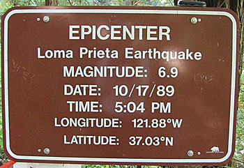
Not long after geologists determined that the epicenter was in The Forest of Nisene Marks, a small unofficial sign appeared in the general vicinity of the coordinates given. Ranger Jerry Waggoner later replaced it with a hand painted sign, which has since been replaced by the official sign that stands there today. However, because the epicenter is approximately 11 ½ miles below the earth’s surface, it is nearly impossible to mark the exact location.
As we commemorate the 25-year anniversary of the 1989 earthquake this October, I urge you take this opportunity to create, review, and/or update your emergency plan for all potential natural disasters.
•••
For more information about the Aptos History Museum, upcoming events, or becoming a member of the museum, please visit www.aptoshistory.org.