

Highway 17 Wildlife Public Information Meeting
Wednesday, May 2 • 6 to 8 p.m.
Scotts Valley Senior Center (Main Room)
370 Kings Village Road Scotts Valley

The purpose of the $5.6 million project is to provide for safe movement of wildlife under highway 17 for wildlife habitat connectivity and wildlife mobility by connecting two core habitat areas along this stretch of Highway 17.
The community is invited to attend a presentation and Q & A session regarding this project, which is funded in part by Measure D. Join Caltrans on May 2, 6-8 p.m. at the Scotts Valley Senior Center, 370 Kings Village Road, to learn more about the project cost, schedule and scope.
At 6:00 p.m., Caltrans Project Manager will gather the audience and provide a brief introduction about the project cost, schedule and scope. Caltrans Biologists will provide a presentation on the background and early development and coordination of the project.
Following the presentation the meeting will be open to a question and answer session. Caltrans project team members, along with members of the Land Trust of Santa Cruz and the Santa Cruz County Regional Transportation Commission will be available to answer questions.
High Annual Average Daily Traffic volumes (57,000 vehicles per day) combined with a concrete median barrier and a lack of adequate culvert or bridge undercrossing contributes to a high frequency of animal-vehicle collisions (AVC’s) along Highway 17.
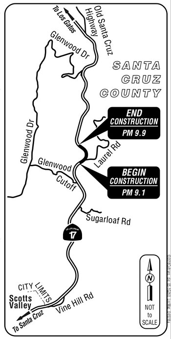
Using GPS/radio telemetry, wildlife camera data and road kill data; the curve at Laurel Road has been identified as one of the best locations along the Highway 17 corridor in which a Hwy 17 bridge with a wildlife highway undercrossing would provide the greatest benefit.
At the project location the Land Trust of Santa Cruz County has preserved 460 acres of mostly undeveloped land on both sides of the highway in a conservation easement.
•••
For more information about this project or about the meeting, please contact Aaron Henkel, Project Manager, at (805) 549-3084.
For other transportation matters, please call the District 5 Public Affairs Office at (805) 549-3318.