

Santa Cruz County Regional Transportation Commission On the Move
By Noel Smith
Highway 1
 appears for a ground-breaking event for the La Fonda Bridge.")
Dondero was surprised by the community’s response to the official opening of the new La Fonda Bridge over highway 1, which was a major part of the project. “We knew it would be a big inconvenience especially for school kids and their parents with a major school at either end, Harbor High School and Delaveaga Elementary School. We arranged for shuttle buses, ridesharing and even bicycle trailers. When we had the grand reopening, we figured on several dozen people showing up but there were over 500 people there to celebrate the event. There was also a cake but not a crumb was left when it was all over. And the people were great. They appreciated what we had to deal with during the construction.”
According to Sr. Transportation Planner, Karena Pushnik, the next section of Highway 1 scheduled for auxiliary lanes will be from Soquel Avenue to 41st Street. “The current plan is to add these lanes, section-by-section, out to San Andreas Road.”
Monterey Bay Sanctuary Scenic Trail Network
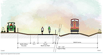
Rail Transportation
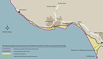
A project now underway and expected to be completed this coming fall is the rehabilitation of the La Selva trestle. This will allow the rail corridor to again become a viable transportation alternative for freight and eventually passenger use. It is expected that the Santa Cruz and Monterey Bay Railway Company (Iowa Pacific) will be running excursion and dinner trains by along some stretches of the 32-mile long SCCRTC owned corridor by 2016.
Complete Streets Guidebook
To help local transportation planning, the Complete Streets Guidebook has all the criteria for integrating the needs of all forms of transportation. Thus city streets that must have room for cars, pedestrians, bicyclists, bus riders and have to take into account the special needs of schools and seniors have proven standards in the guidebook that meet all these needs.
•••
Something for Everyone on the Move!
Courtesy Santa Cruz County Regional Transportation System
![]()
On the right hand side of the home page is the Commute Solutions area. Here you will find the Commuter HelpDesk. For commuters it is full of information about ridesharing (carpooling), vanpooling, park and ride and alternatives to driving. If you are a student, there is the Getting to School section that has all the transportation options from K through college. The college section is arranged by school, which includes UCSC, Cabrillo College and San Jose State.
For those looking for transportations options, there is the Getting Around menu which has information on walking, bicycling, taking the bus both local & area-wide, driving, and transportation for seniors and for travelers.
Under Commute Solutions, select Traffic Conditions to view the Caltrans Quickmap. The Quickmap shows traffic conditions throughout California. Choose the area you want, and then select the type of information such as slow/fast traffic condition, lane closures and traffic incidents. You can even see screen shots or real-time videos of traffic on our highways.
And then there is the Bike Maps link under Commute Solutions that has some of the best maps for bikers and really for anyone wanting good maps of the county and its cities.
Good getting around Santa Cruz County and be sure to visit www.sccrtc.org for local transportation information.