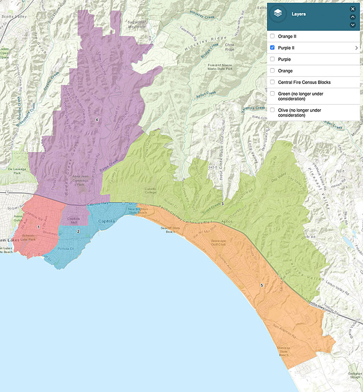
On Feb. 10, the Central Fire District Board of Directors opted to move forward with one of the maps presented by National Demographics Corp. drawing boundaries for 5 areas of representation for the future elections.
The map chosen is “Purple II” (above).
 The map divides Central Fire into 5 areas, each with a nearly equal population and taking into account common issues, natural dividing lines and common needs and hazards.
The new voting system is designed to comply with the California Voting Rights Act and avoid lawsuits that have been expensive in other jurisdictions.
The voting public will be able to elect a director who lives in their area, to ensure the best representation for that area’s needs.
The next step in moving to this new district-based election system is to submit the map to the Santa Cruz County Recorders Office for approval.
Central Fire District leaders expect to have the new areas approved and implemented for the November 2022 election.
Residents can view the “Purple II” on Central Fire’s interactive map page, and enter their address at the top left to see which represented area their property is going to be part of: https://tinyurl.com/central-fire-purple-2
The map was chosen following four public hearings.
Four maps were initially presented by NDC, then two more (Orange II and Purple II) after input from the board and public.
At the fourth public hearing, all six maps and two alternates presented by a member of the public were all viewed and discussed before deciding the “Purple II” map was the most appropriate.
•••
For information on the decision-making process, including draft maps of the proposed areas and how to give feedback, visit www.centralfiresc.org/2279/Re-Districting-Process-2021-2022.


