By Sam Storey, Mayor, City of Capitola
On Jan. 14, 2022, we were reminded once again of the awesome power of Mother Nature. That day the Hunga Tonga-Hunga Ha’apai submarine volcano erupted with a force greater than multiple atomic bombs.

Hunga Tonga is 5,380 miles from Capitola yet the next day we saw and felt the results of that eruption. Thank our lucky stars that the tsunami was not high enough to come over Capitola’s Esplanade seawall.
It was another warning sign from Mother Nature and raises the question if we can do something to protect Capitola Village before the next one hits. Because its not a matter of “if” but a matter of “when.”
After the volcanic blast, the National Oceanic and Atmospheric Administration issued a Tsunami Advisory at 4:53 a.m. on Jan. 15. Acting on that advisory, Capitola Police and Central Fire coordinated their efforts to monitor and respond to the situation.
In December 2021, the City of Capitola had installed a remote water height monitor on Soquel Creek that measures the water height and flow. It allows the City to remotely monitor the water flow and collect that data over time.
The initial shockwave from the blast came through Capitola around 4 a.m. causing a spike in barometric pressure.
Fortunately no homes along the creek or in the Village were flooded.
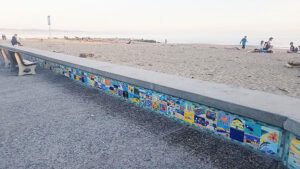
Undoubtedly, if it hadn’t been for the current seawall on Esplanade Drive, Capitola Village would have been flooded.
The current seawall along the Esplanade was built in 1986 and we have former Capitola leaders to thank for their foresight in providing that measure of protection. That project was made possible by a grant from the Coastal Conservancy and has served Capitola very well.
Hunga Tonga in loud terms raises the question of whether it is still adequate in an era of sea level rise. The Esplanade seawall is 23” high on the sidewalk side and varies in height on the ocean side depending on the height of the beach and the tides. Sometimes and in some places the wall is not much more than 23” high from the beach on either side. That’s not much margin for error where tsunamis are concerned.
In 2011, NOAA issued a Tsunami Warning for our region due to a 8.9 magnitude earthquake in Japan. The Tohoku Tsunami had major impacts all along the California coast and has shaped some of our tsunami preparedness policies.
If you would like to see the results of that tsunami visit the California Geological Survey online for “California Impacts from the 2011 Tohoku Tsunami” and view their multimedia tour.
The Geological Survey website also has a Tsunami Hazard Area Map. You can click on that map and see the areas that are susceptible to tsunami inundation. For Capitola, that includes all of the Village up beyond the trestle and up Soquel Creek to Highway 1.
There is no stopping a tsunami; there is only what we can do to prepare and how we react when they happen.
Check to see if you live in a tsunami inundation area and, if so, have a preparedness and evacution plan. Purchase flood insurance if you can. Make sure you are able to receive Nixel alerts from your local police or sheriffs office. In the event of a Tsunami Advisory or Warning follow the official instructions and try to avoid threatened areas — go to higher ground! Check on and assist those that may be unable to evacuate.
Now back to the Capitola Esplanade Seawall. An Esplanade Seawall upgrade project is listed in Capitola’s Local Hazard Mitigation Plan. However, it is identified as a “low” priority project.
After our wake-up call from Hunga Tonga, the Capitola City, Village property owners, and the Coastal Commission may want to reconsider raising this priority level and work together to shore up our coastal defenses. The details of getting that done are beyond the scope of this article. However, if we start now, we may be better prepared when the next and potentially bigger tsunami comes our way.
•••
Sam Storey is mayor of Capitola. Contact him at samforcapitola@yahoo.com.
Photos Credit: City of Capitola