

By Jon Chown
A new plan to prepare the Pajaro River watershed for intensifying droughts, floods and other environmental pressures has been released by the Pajaro Valley Water Management Agency, and it calls for additional tax revenue.
The Pajaro River Watershed Resilience Plan, developed through the Pajaro River Watershed Resilience Program, lays out a comprehensive strategy to strengthen climate resilience across the watershed, which stretches through Santa Cruz, Monterey, San Benito and Santa Clara counties.
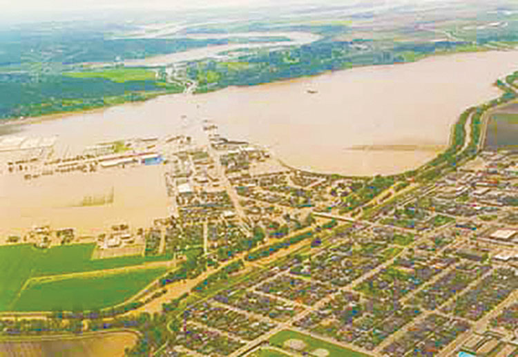
Pajaro River Flood • 1995
The watershed was selected in 2024 by the California Department of Water Resources as one of five pilot regions for its Watershed Resilience Program, an initiative designed to test new approaches to managing water resources and climate risks at a broader geographic scale. Funding for the planning effort was provided through the state budget.
The plan reflects input from a wide array of stakeholders, including public agencies, tribal representatives, farmers, environmental organizations, nonprofits and local residents. More than 700 participants contributed to the effort through what organizers described as a “watershed network,” with 15 entities serving on an advisory group. The result is a detailed plan to address a range of challenges, including flooding, prolonged drought, groundwater depletion, habitat loss and declining water quality.
“The PRWRP reflects the shared commitment of watershed partners to work toward coordinated, multi-benefit solutions for climate resilience in the watershed,” said Brian Lockwood, general manager of the Pajaro Valley Water Management Agency. “By aligning priorities and working together, we strengthen the region’s ability to acquire funding, implement projects, and deliver meaningful benefits to communities, agriculture, and ecosystems.”
Climate Threats Intensifying
The plan arrives as the Pajaro River watershed faces mounting evidence of climate stress.
In recent years, the region has experienced a series of extreme weather events, including major droughts, intense wildfires, floods due to atmospheric rivers and coastal flooding driven by sea level rise. These events have exposed vulnerabilities in not just the infrastructure, but land use patterns as well.
One of the most significant recent disasters occurred in March 2023, when a levee along the Pajaro River failed, sending floodwaters into the community of Pajaro. Approximately 3,500 residents, many of them farmworkers, were displaced, and 278 homes were inundated. The flooding caused millions of dollars in damage to infrastructure and agriculture and released an estimated 800,000 gallons of untreated sewage into the river system, which ultimately drains into Monterey Bay.
Officials say the event served as a stark reminder of the need for proactive investment in resilience.
“The levee failure alone underscored how urgently we need to reduce risk and invest in resilience before the next storm or extended drought,” the report states.
While photos and video of the flood captured public attention, the plan identifies drought as the most significant long-term threat to the watershed. A comprehensive vulnerability assessment of 525 assets across the region found that 42% are highly vulnerable to drought conditions, far higher than for any other climate hazard. Wildfire and sea level rise each accounted for 19% of high vulnerabilities, followed by extreme heat at 13% and flooding at 7%.
The findings reflect the region’s heavy dependence on groundwater. Approximately 90% of the watershed’s water supply comes from underground sources, and about 84% is used for agriculture, which is the economic backbone of the area.
The plan also points out that past droughts in the region have lasted as long as 13 years, far longer than those observed in modern records. When combined with future climate projections, those extended drought scenarios could become even more intense, increasing long-term drought frequency by as much as 30% to 100%.
A System Under Strain
The Pajaro River watershed is shaped by a complex network of rivers and tributaries, including Pacheco, Llagas, Uvas, San Benito and Salsipuedes-Corralitos creeks. These waterways originate in surrounding mountain ranges and flow into the Pajaro River, which serves as the region’s primary drainage system.
Most of the watershed’s precipitation comes from a small number of intense atmospheric river storms, creating a pattern of extreme variability. Wet years can bring significant flooding, while dry years can lead to severe water shortages.
This variability, combined with the effects of climate change, presents a growing challenge for water managers.
In the report, longtime grower Peter Van Dyke, whose family has farmed in the region for generations, described how the landscape has changed over time. He pointed to shifts toward more water-intensive crops, such as strawberries, and the impact of fast-moving stormwater on farmland, noting that upstream development has altered natural water flows and increased runoff.
“The watershed has taken a beating,” he said during the planning process, according to the report.
The watershed’s vulnerabilities extend beyond water supply. Decades of development in both flood-prone and water-stressed areas, along with the channelization of rivers and loss of natural floodplains, have increased exposure to flooding and reduced the landscape’s ability to absorb and store water.
Urban expansion into the wildland-urban interface has heightened wildfire risk, while agricultural practices and changing land use patterns have contributed to soil degradation and increased pressure on groundwater.
Water quality is also under threat, particularly in coastal areas where seawater intrusion is contaminating groundwater supplies. Rising sea levels are expected to exacerbate the problem, pushing saltwater further inland and raising groundwater tables, which could lead to additional flooding and infrastructure damage.
From Planning to Action
To address these challenges, planners identified 13 “Keystone Actions” as top priorities. These initiatives were selected based on their ability to address multiple vulnerabilities at once, deliver benefits across different systems and communities, and advance equity — particularly for historically underserved populations and tribal communities.
Among the proposed solutions are large-scale floodplain restoration projects designed to reconnect rivers with their natural floodplains. Restoring wetlands and riparian corridors can provide multiple benefits including flood protection, groundwater recharge and habitat restoration. Other strategies include expanding managed aquifer recharge, increasing the use of recycled water, and implementing conservation measures to reduce demand.
In urban areas, the plan calls for “green streets” and low-impact development approaches that capture and infiltrate stormwater, helping to reduce runoff and improve water quality.
Agricultural land stewardship is another key focus, with recommendations aimed at improving soil health, increasing water efficiency and exploring voluntary land repurposing in areas that are no longer sustainable for intensive farming.
A central theme of the plan is the importance of equity and inclusion, particularly in relation to tribal communities and underserved populations.
The plan calls for increased tribal access to culturally significant lands and the development of co-stewardship agreements that incorporate traditional ecological knowledge into land and water management practices. It also highlights the need to improve public access to outdoor spaces, which are increasingly threatened by climate impacts such as extreme heat, wildfire and coastal flooding.
However, the plan acknowledges that implementing all of these plans will be difficult as many agencies and community organizations face limited staffing, funding and technical ability.
Funding the Future
One of the most significant challenges identified in the plan is how to pay for the extensive work required. To address this, the plan proposes a mix of philanthropic fundraising and increased taxes.
In the first phase, covering roughly the first two years, funding would focus on building organizational capacity, including staffing, project development and early technical studies. This stage would rely on a combination of local agency contributions, nonprofit support and philanthropic funding.
The second phase, spanning years two through four, would focus on securing state and federal grants to support planning, design and construction of projects. The final phase, beginning around year four and continuing long term, would require what the agency terms as “stable, locally controlled funding sources” to support operations, maintenance and monitoring. Basically, this means new taxes or increased taxes. Potential options include increasing rates for water use, parcel-based fees, development impact fees, or other voter-approved measures.
The report says establishing “reliable funding streams” will be critical to ensuring that projects can be maintained and adapted over time.
The plan concludes with a call to action, emphasizing that the time to act is now. Without coordinated efforts, the report warns, climate impacts will continue to intensify, placing increasing strain on communities, ecosystems and the regional economy.
“Action now can protect people, places, and livelihoods across the watershed,” the report states.